
The cliff path is the toughest walking section on the island but well worth it! If you were to start on the east side of the island heading away from Belvoir this is how you find the 'viewpoint' I have previously reffered to. I have now captured this at low tide clearly showing both Belvoir and Shell Beaches (click on the image to go to Flickr and see the larger version!)
Here's a few pictures that give you an idea of how the path goes.


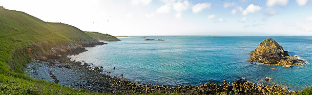
Then you can also see down into little coves, inaccessible by land, one of which is puffin bay but I'm not sure which!


These pictures have Sark Island in view over the water as you look out east but as you scoop round the bottom of the south end heading west you hit some steps...

That bring you out to another favourite spot of mine where it opens out at what must be the south west tip of Herm where you can see Jethou Island and Guernsey further in the distance.

The low sun in this picture really captures how I always see this spot on my walks after work!
Finally, before going full circle and getting back to the front of the island and the harbour beach you reach Rosiere Steps, this is where the ferry docks at low tide. You can see them on the left.

And that is it! I've pretty much photographed every beauty spot on the island now... For those of you who know Herm well, have I missed anything?...
I'm still working on the inland stuff and I think I'll try a collection on fields and buildings next but you can't keep me away from the sea too long!
Until next time...
Great photos Sarah. Nice to meet you on the island this week. I'm about to start processing my photos. I'll send you the link to my Flickr account when I've uploaded them.
ReplyDeleteKeep the blog posts, and the photos, coming, and enjoy the Summer.
Alan Rowley
Thanks Alan! It's always nice to meet someone who's seen my blog :) I look forward to seeing your pics.
Delete